Marlingford Gravel Extraction


NCC Consultation blurb

Marlingford site details

Consultation - Norfolk Minerals and Waste Local Development Framework

The latest consultation on the below documents is currently underway:

Norfolk Minerals Site Allocations: Further Issues and Options stage (Preferred Options) - The consultation period is between 19 October and 5pm on 11 December 2009. To respond please click on the view consultation documents button below.

Norfolk Waste Site Allocations: Further Issues and Options stage (Preferred Options) - The consultation period is between 19 October and 5pm on 11 December 2009. To respond please click on the view consultation documents button below

 Click here to view the above mentioned planning documents that are currently being consulted on. All the comments made during the previous consultation period are now available to view on the website (click on the magnifying glass icon in the online document). We have summarised the comments into the issues raised for each site and responded. These summaries are available to view as part of the supporting documents for the current consultation.

We think it is important to involve Norfolk’s communities and others in developing our minerals and waste policy. Across Norfolk there is a wealth of knowledge, experience and interest, as well as concern about minerals and waste. So whether it’s your own experiences, or detailed knowledge of minerals extraction or waste management, or your appreciation for your local community or your favourite beauty spot, you have a lot to offer this plan making process.

All previously-made comments are still valid and will be taken into account in deciding the final shortlist of sites later; a re-submission of your previous consultation response is therefore not necessary.

However, you may wish to comment on or challenge the rationale behind the decision on certain sites, even if the nature of your response is largely unchanged.

The Previous stage of consultations on the Minerals and Waste Development Framework were:

Norfolk Minerals Site Allocations: Issues and Options stage - The consultation period was between 15 February and 25 April 2008.

Norfolk Waste Site Allocations: Issues and Options stage - The consultation period was between 15 February and 25 April 2008.

Norfolk Minerals and Waste Core Strategy and Development Control:

Issues and Options stage – The consultation period was held between 14 May 2007 and 25 June 2007.

Preferred Options stage - The consultation period was held between 15 February and 28 March 2008.

The publication document is now planned to be published in mid 2010, with the opportunity to comment on the soundness of the document, during a twelve week period. This will be followed by an Examination in Public later in the year.

Frequently Asked Questions (FAQs) on MINERALS AND WASTE CONSULTATION DOCUMENTS October 2009
2008 updates to the Mineral Allocation Sites
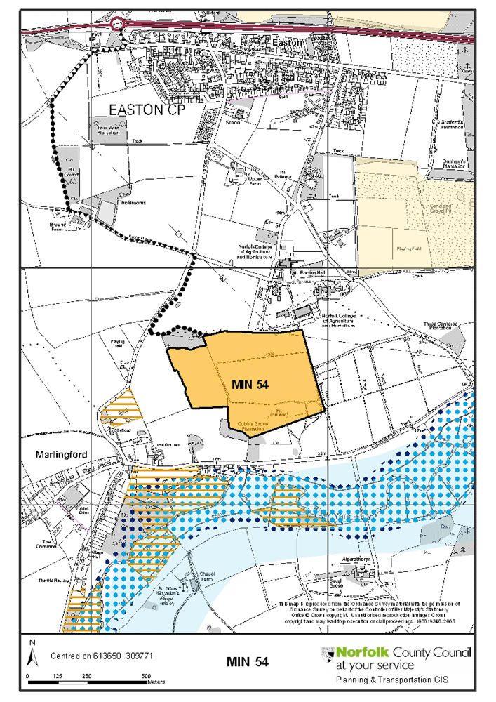
See image

Site Ref No.

MIN 54

Parish

MARLINGFORD and COLTON

Location of site

Land to the North of Bawburgh Road, Marlingford, Norwich

Submitted by

The Lombe Estate Trust, represented by Stephen M Daw Ltd

Proposed use/s

Mineral extraction (sand and gravel), concrete batching plant, aggregate processing

Estimated Reserve

735,000 tonnes

Allocation / Area of Search

Allocation

Size of site (ha)

20.6

Background Information: - No current mineral or waste planning permission on the site. The submission states that: "Views from Easton College and its associated sports pitches will be screened by a combination of advance landscape planning and carefully designed bunding. Afteruse of the site will be to arable land with wide field margins, mixed species hedgerows and blocks of lowland mixed deciduous woodland"

Landscape: - Site could be screened satisfactorily; noise impact could be mitigated by not including noisy work on southern side of site. Restoration to farmland with blocks of woodland would be acceptable in landscape terms

Ecology: - Ecology could be improved through restoration to cereal field margins, hedgerows and woodland

Highways: - Access arrangements suggested by proposer are: a haul road to Marlingford Road/Broom Lane junction, improvements to Broom Lane (through Broom Farm) and then up to A47 (i.e. avoiding Easton village). This is acceptable to the Highway Authority

External Consultees Comments

English Heritage: - The setting of a Grade II* listed building to the south-west of the proposed site is likely to be detrimentally affected by minerals operations here
Highways Agency - MIN54 from which minerals traffic may seek access to the trunk road at an at-grade junction: the roundabout where the A47 meets Dereham Road at Easton. Although Site MIN54 is relatively large, NCC state that there is an option proposed in the submission for this site to create a haul road across the Yare Valley to the undesignated C168 Mill Road to the B1108, Watton Road, a main distributor road. If this an option taken forward, it is unlikely that this site would have a significant impact upon the A47/Dereham Road junction at Easton. Without a haul road, there may be a need for an assessment
Norfolk Geodiversity Partnership: - Traffic impact upon rural roads

Public/parish Council comments: - The main concerns raised were unacceptable highways impacts, damage to the Yare valley landscape, and harm to wildlife

Conclusions: - This site is considered to be acceptable, subject to the noise impact on Bawburgh Road residents to the south being mitigated to a satisfactory level by the appropriate siting of plant material and screening, the proposed restoration type being followed, and that the proposed access route is used.


Older details
 

See image

Site Reference No.

MIN 54

Parish

MARLINGFORD and COLTON

Location of site

Land to the North of Bawburgh Road, Marlingford, Norwich Grid reference: 6134, 3095

Submitted by

Bidwells on behalf of The Lombe Estate Trust

Proposed use/s

Mineral extraction (sand and gravel), concrete batching plant, aggregate processing

Size of site in hectares (acres)

20.57 (50.83)

Estimate reserve (minerals)

735,000 tonnes

Allocation / Area of Search

Allocation

Current planning status: - No current mineral or waste planning permission on the site.

Landscape and Ecology: - The site is not within or in close proximity to any national nature conservation or landscape designations. It is a plateau of agricultural land, used in part for pig farming. The land slopes downwards to the south and west. There is a block of woodland in the north-west corner and a number of individual trees within the site. The site is in rolling, mainly arable countryside. The River Yare is to the south of the site. Easton Agricultural College is to the north-east and its sports pitches are to the east of the site. The village of Marlingford is to the south-west and Easton is to the north. The allocation would have potential to affect protected species or their habitats (refer to list in the evidence base).

Highways: - The site is located near to the undesignated C168, Marlingford Road to the west and the undesignated C162, Bawburgh Road to the south. The C168 is approximately 1.4km from the A47 and the C162 about 2.8km from the A47. Another option proposed in the submission is to create a haul road across the Yare valley to the undesignated C168 Mill Road which is 1-1.5km along Mill Road to the B1108, Watton Road, a Main Distributor route.

Archaeology: -Some archaeological investigation work needed, which could be required by a condition to planning consent.

Additional Information submitted: - According to the submission the haul route option put forward with the proposal 'may be varied' (see above).

Any other issues or comments